 |
Maps of the Americas & Regions Within at Aquila Books
|
|
|
Books ~ Ephemera ~ Artwork ~ Manuscripts ~ Maps ~ Photographs ~ Charles Van Sandwyk ~ Catalogues Fram Museum Publications ~ Artifacts, Antiques, Collectables & Scientific Instruments ~ Aquila Publishing ~ L. M. Montgomery
About Aquila ~ Want Lists ~ Ordering ~ Selling to Aquila
|
|
If you wish to sell something in this category, looking for something specific you do not see or have any questions please contact us.
Scroll down to see our complete collection of maps showing the Americas and regions within or jump to a particular section: Maps of Canada Maps of Canadian Areas: Calgary Louisburg Montreal/Expo 67 British Columbia & Vancouver Island Maps of US areas: Washington Maps of the Americas: North-West America North America South America
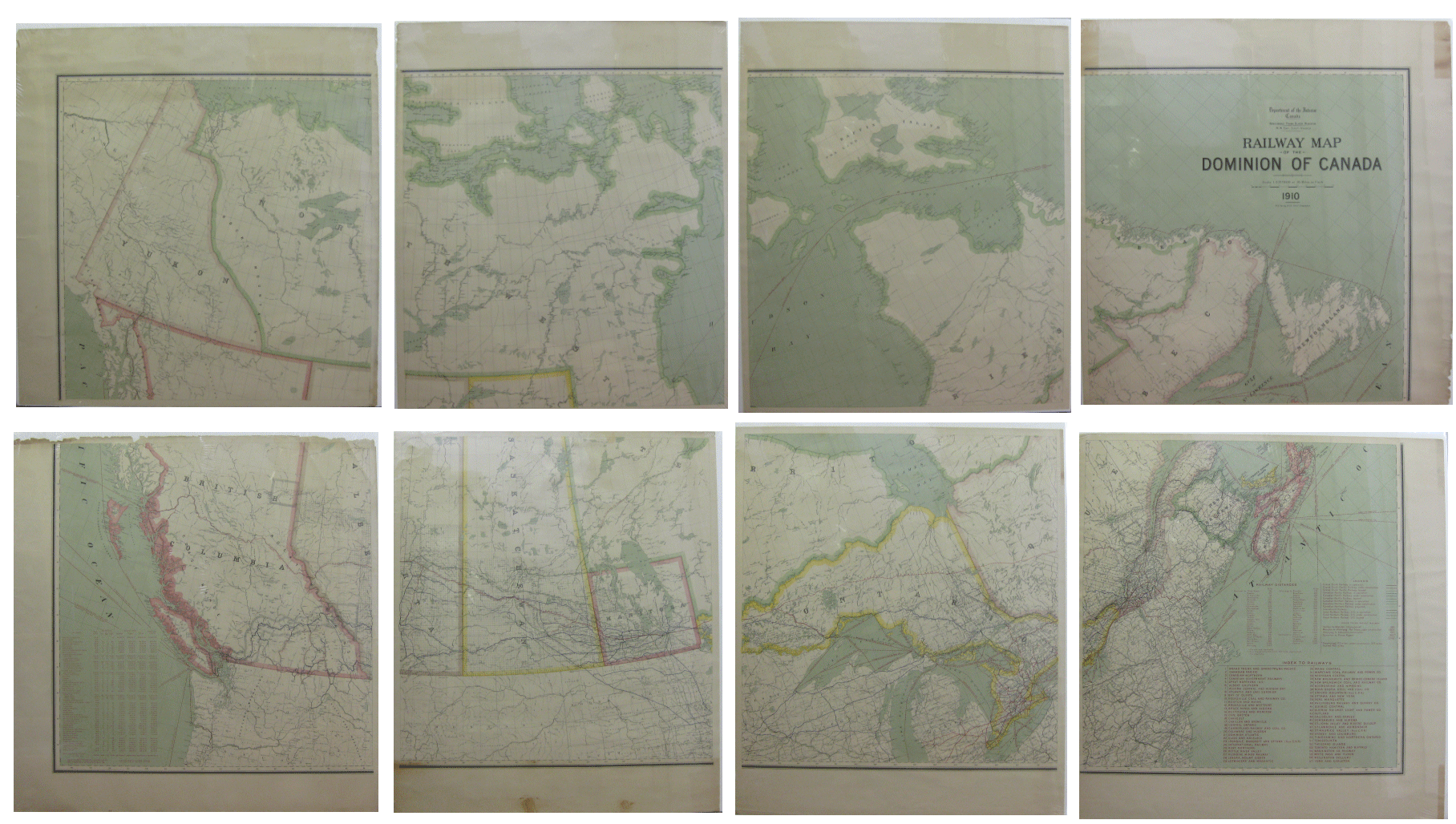
Young, R. E. Railway Map of the Dominion of Canada. 1910.
Honourable Frank Oliver, Minister. W. W. Cory, Deputy Minister [Original 1910 Map in Eight Parts].Department of the Interior Canada, 1910, Original 1910 Map in 8 Seperate parts. Very good. Eight seperate sheets each measuring roughly 31" X 29.5" (78.75 X 75 cm). Some discolouration and mild chipping to the edges though generally not intrusive past the margins. Soft colouring. Slight rippling. A nice looking set.
An interesting and very large map showing the Railway Dominion of Canada. Relief shown by spot heights. Includes "Index to railways" and "Table of railway distances.". Aquila Books # 136478.....$1500.00
MAPS OF SPECIFIC AREAS WITHIN THE AMERICAS
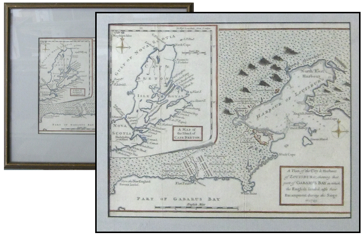
A Plan of the City & Harbour of Louisburg; Showing That Part of Gabarus Bay in Which the English Landed, Alfo in Their Encampment During the Siege in 1745. With Inset Map of the Illand of Cape Breton
[Original Map].London: Gentleman's Magazine, 1758. Near fine. Original map. Hand coloured. 8" X 9.75" (20.3 X 24.75 cm). In thin wooden frame with some mild wear, especially at edges. Frame measures 13.75" X 15.75" (35 X 40 cm). Light gray matting. Map has a few light, vertical creases. Delicate hand-coloured detailing with inset of Cape Breton to the top left. Title on the bottom left. Distance in English miles. A nice map. Mountains signified with small illustrations.
A beautiful map showing part of Gabarus Bay and the Harbour of Louisburg as well as the city of Louisbourg and surrounding area. To the top left an inset shows Cape Breton or Isle Royal off of the tip of Nova Scotia. It is bordered by the Gulf of Nova Scotia.
The map was printed in Gentlemen's magazine- an English publication which ran from 1731-1922.
The Siege of Louisbourg took place in 1745 when a New England colonial force aided by a British fleet captured Louisbourg, the capital of the French province of Île-Royale (present-day Cape Breton Island) during the War of the Austrian Succession, known as King George's War in the British colonies. Aquila Books # 135178 - SOLD $150.00
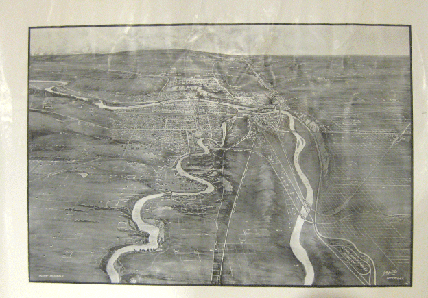
Burton, H. M. Canadian Cities: Birds Eye Views. Calgary
[Original 1910 Map]. Calgary: Calgary Engraving Co., 1910. Very good. Original Illustrated 1910 Map. Grayscale with relief shown by shading. Major rivers and roadways are labeled. Printed on eggshell paper. Some light soiling as well as some creasing and wrinkling (especially nearer edges). A nice original copy.
Map shows Calgary in 1910 with the majority of buildings clustered around downtown and sparsely elsewhere. A facsimile version was printed in 2004 by the University of Alberta/Sponsored by Aquila Books. Very interesting when compared with it looks like today. A beautiful old Calgary map.
Aquila Books #134888 - $600.00
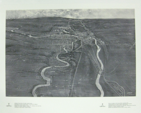
Burton, H. M. Canadian Cities: Birds Eye Views. Calgary [1910]
Ottawa: The Association of Canadian Map Libraries and Archives, 2004, reproduction. Fine. Illustrated 1910 map facsimile. Grayscale with relief shown by shading. Major rivers and roadways are labeled. Printed on eggshell paper. In fine condition.
Reproduction from an original in the William C. Wonders Map Collection, University of Alberta, Edmonton, Alberta. Sponsored by Aquila Books in Calgary, Alberta. Information below map is in English on the left side and French on the right. Map shows Calgary in 1910 with the majority of buildings clustered around downtown and sparsely elsewhere. Very interesting when compared with it looks like today. Aquila Books # 134736 - $25.00
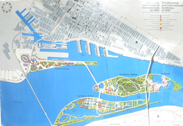
The Canadian Corporation for the 1967 World Exhibition. The Universal and International Exhibition of 1967. April 28 - October 27, Montreal, Canada
[Original Map]. Montreal: The Canadian Corporation for the 1967 World Exhibition, 1967, Original Map. Fine. 22" X 32" (56 X 81 cm). Bright colours. Clean and crisp with only the slight wear along edges. A fine copy.
Bright, clear map with interesting illustrative style. Map shows the island where Expo 67 took place (in Montreal) and surrounding area. Colourful coding shows where the main pavilions were set up. The 1967 International and Universal Exposition or Expo 67, as it was commonly known, was the general exhibition, Category One World's Fair held in Montreal, Quebec, Canada, from April 27 to October 29, 1967. It is considered to be the most successful World's Fair of the 20th century, with the most attendees to that date and 62 nations participating. It also set the single-day attendance record for a world's fair, with 569,500 visitors on its third day.
Aquila Books # 136465.....$125.00
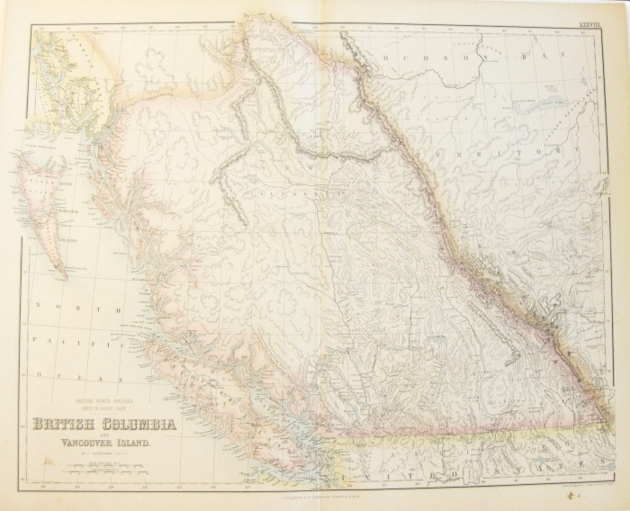
Fullarton A., & Co. / Bartholomew, J. British Columbia and Vancouver Island. British North America Sheet III Pacific Coast. By J. Bartholomew, E. R. G. S.
[Original Hand-Coloured 1860 Map].Edinburgh, London & Dublin: A. Fullarton & Co. / Drawn and Engraved by J. Bartholomew, 1860, Original hand-coloured 1860 map. Near fine. 18.75" X 23.25" (47.5 X 59 cm). Detailed map on thick paper with subtle hand colouring. Slight discolouration around edges, vertical crease down center and four small stains. Generally in excellent condition.
Atlas map. Originally from the Royal Illustrated Atlas, of Modern Geography. Map shows Pacific Coast, Hudson Bay territory, Indian territory, British Columbia, New Caledonia, Vancouver Island, Russian America, and the United States. A large portion of the map is Hudson Bay Territory (dissolved in 1870), shown occupying the region east of the Rocky Mountain and north of the Simpson or Babine River. Excellent detail throughout British Columbia locates mountains and watershed, many towns and villages, roads and trails, Indian Tribes, and more. Aquila Books # 136471.....$225.00
|
|
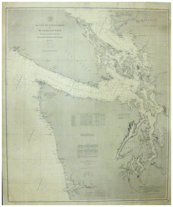
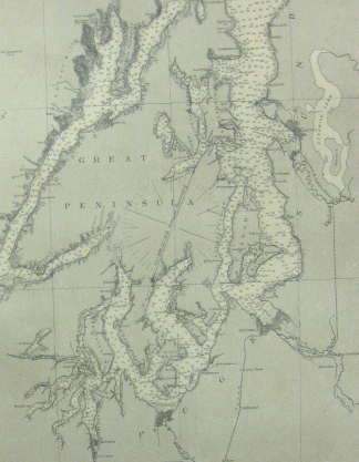
United States Coast and Geodetic Survey. Sea Coast and Interior Harbors of Washington. From Gray's Harbor to Olympia Including Washington Sound.
[Original 1890 Map]. Seattle, W. T.: United States Coast and Geodetic Survey, 1890, Published January 1888, reprinted March 1890. Good. 41" X 34" (104 X 86.3 cm). Large map with black printing upon light brown paper. Light blue stamp from "W. H. Rumphrey, Book Sellers and Stationers, Seattle W. T." beneath title. Another light blue stamp to bottom left corner reads "Corrected to Mar 5 1890". Light creasing and rippling in many spots across map (with concentrated creasing near edges). Chipping and small closed tears, especially at corners, as well as a 14.5" closed tear running up from center of bottom of map. Map has been laid down on cloth with some professional restoration to corners.
Scale 1:300 000. (Provides reference for Statute miles, Nautical miles and kilometers). Small charts printed on it with information regarding lights, buoys, tides, soundings, authorities, telegraph signal station and abbreviations. A very detailed map which offers a wealth of information.
Aquila Books 134827 - $400.00
|
|
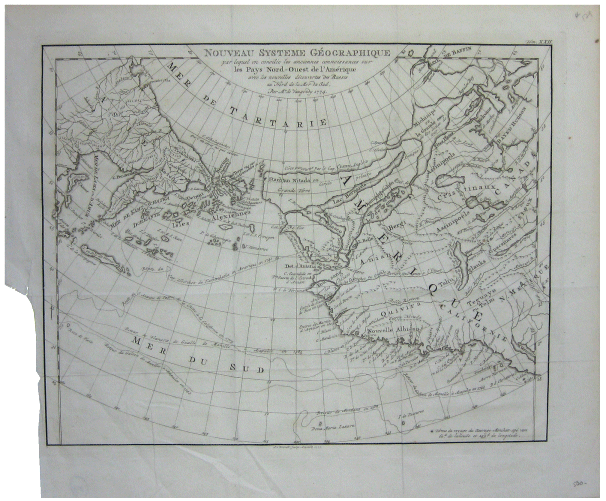
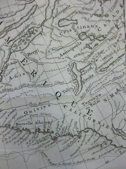
Above- Full map, below- close up of small section
Par Mrde. Vaugondy Nouveau Systeme Geographique Par Lequel on Concilie Les Anciennes Connoissances Sur Les Pays Nord-Ouest de L'amerique Avec Les Nouvelles Decouvertes Des Russes Ar Nord de la Mer Du Sud. [Original 1777 Map Showing North-West America with the New Russian Discoveries North of the South Sea in French].
Amsterdam: A. V. Lrevelt, 1777. Good to very good. 14.25" X 16.5" (36 X 42 cm). Printed on thin paper. Two vertical and three horizontal creases, along with some general wrinkling. Slight darkening to top and right edges. Piece missing from left side (1 inch in and 6.5 inches up the side), though does not affect the map.
A detailed and elegant map depicting North Western America (cut off on the left at California, through New Mexico and up to the islands above the Hudson's Bay) and the tip of the Russian Empire to the left with many small islands. Beautiful, dainty lettering and detail.
Aquila Books #134847 - $500.00
|
|
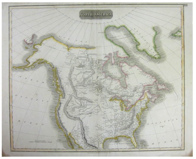
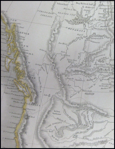
Above- full map, Below- detail closer up
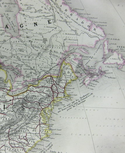
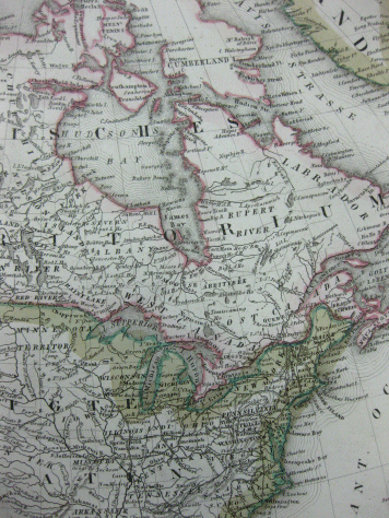
Hewitt, N. R. North America [Original 1814 Map].
London: Thomsons New General Atlas [Drawn and Engraved For], 1814. Very good. 21" X 26" (53.34 X 66 cm). Printed on thick paper. The edges of the land masses have been outlined by hand in colour (pink, yellow and green). Vertical crease down center with some very slight darkening to either side. Light soiling near edges (with the tips of the bottom two corners darkened). Border has been coloured a very subtle orange, which gets darker near to the top right corner; also No. 53 sticker further into top right corner. Bottom edge untrimmed with a couple of small closed tears. A very interesting map.
Map shows North America (with the borders being: the easternmost tip of Asia/the islands of Alaska, the western most tip of Iceland and New Mexico). The yellow outline surrounds the continent of North America except for Eastern Canada. The pink border starts at Lake Superior, running across the Great Lakes, along the Canadian east coast and up to Repulse Bay - including Nova Scotia and Newfoundland). Interestingly the small eastern tip of Asia visible to the left of the map is also outlined in pink making it unclear what the boundaries signify. Greenland and Iceland are outlined in green. Distance is given in British Statute miles. It is impressive to note the large differences between this map and one of today.
Aquila Books # 134803 - $575.00 |
|
|
|
Above- full map, below- close up of detail
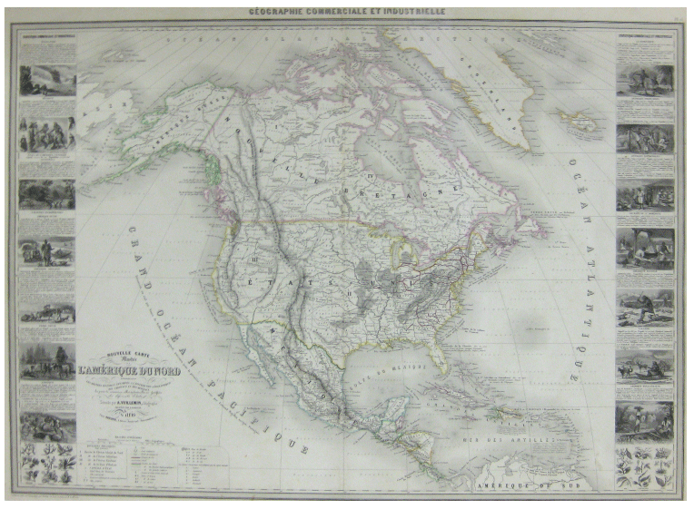
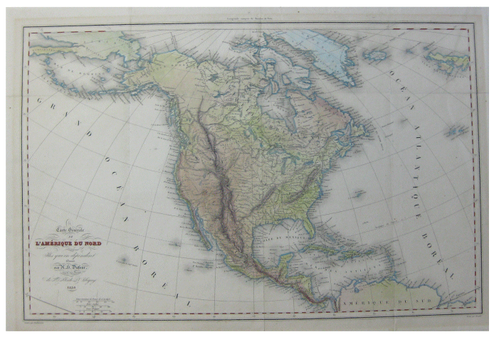
Vuillemin, Alexandre. Nouvelle Carte Illustree de L'amerique Du Nord Indiquant Les Grandes Divisions Physiques, la Distribution Geographique Des Vegetaux et Mineraux.
Paris: Alexandre Vuillemin, 1860. (Map) Very good. Decorative large format map of North America, including 16 decorative side panel vignettes showing indigenous scenes in America, flora, and fauna. Outlines in colour. Scarce. 33" X 24".
The map shows Russian America, Utah and New Mexico extending to the Rocky Mountains, and massive Oregon, Northwest and Indian Territories. Interesting notes on early discoveries, including a reference to Alvaro Nunez in Texas in 1528, Cabrillo discovery of the Paific in 1548, Francis Drake, Lewis and Clark, Edwin James, etc. Early rail roads, forts, canals, military reserves, Indian Lands, ports of commerce and other details noted. One of the most decorative large format maps of North America from the period. Finely engraved by Gerin and illustrated by A. Testard.
Aquila Books 128635 - $1000.00
|
|
|
|
Carte de L'amerique Septentrionale Par Delamarche [Original 1838 Map of North America].
Paris: , 1838. Very good. 18" X 12.5" (45.75 X 31.75 CM) on medium weight textured paper. Horizontal crease across middle that is slightly darkened. Slight soiling with a few small stains. Hand-coloured outlines with yellow border. Cities and a few other spots are highlighted with small red marks.
Longitude du Meridien de Paris. Map shows North America with the tips of Amerique Russe to the top left, Amerique du Sud to the bottom and Groen-Land to the top right. In the bottom left corner is a close up of the Iles Aleutiennes with the decorative title to the bottom right. A vibrant map with many small details.
Aquila Books # 134848 - $300.00 |
|
|
|
Meyer's Hand Atlas. Nord America [Original 1853 Map of North America].
1853. Near fine. Original 1853 map with writing in German. 18" X 14.5" (45.75 X 36.8 cm). Simple square line border surrounding map broken up by a few small bits of land. Hand coloured outlines in a variety of bright shades. Medium weight paper with darkening around edges. A few slightly soiled spots with a small closed tear near the bottom left corner- else in fine condition.
Antique map showing North America bordered by Russian America to the left, the top tip of South America to the bottom and Greenland to the top right.
Aquila Books # 134849 - $400.00 |
|
|
|
Dufour, H. N. Carte Generale de L'amerique Du Nord et Des Iles Qui En Dependent [Original 1836 Map of North America].
Paris: Desbuissons/ Sous la Direction de MR Alcide D. Prbigny, 1836. (Map) Very good. 14.5" X 21" (36.8 X 53.3 cm). Writing in French. Black and red linear rectangular border. Very edges are lightly than the map rectangle. Hand-coloured; land masses have been filled in with light colour and shading shows increases in elevation. Light blue outlines the water. Three vertical creases and one horizontal. A few subtle ripples in some areas.
Map shows North America. The continent is bordered by Siberia to the top left, Greenland the top right and the Northern top of South America at the bottom. A nice map with delicate hand colouring.
Aquila Books # 134851 - $275.00 |
|
|
|
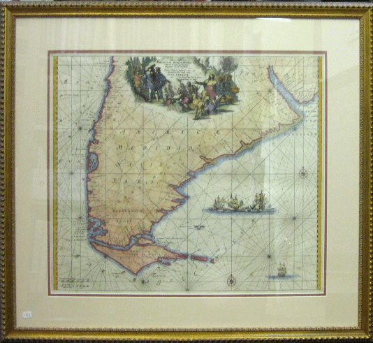
Ottens, Reiner & Josua. Tractus Auftralior Americae Meridionalis a Rio Del la Plata Per Fretum Magellancium Ad Toraltum Nieuve Perfecte Pafeaert Van 'T Suyderlyckfte Deel Van Suyt America Van Rio de la Plata Door de Flraet Magellaen Tot Toral
[Original Map of South America/Tierre Del Fuego]. Amsterdam: 1745. Near fine. Original hand coloured map measuring 19.25" X 22" (48.9 X 55.9 cm). Housed in a thin decorative, carved wooden gilt brushed frame which measures 27.5" X 30" (70 X 76 cm). Light salmon and orange matting. Text in latin. Illustrated with images of ships, people and animals. Vertical crease down center with slight rippling with only a few very small stains. A beautiful map.
Map shows the archipelago off the southernmost tip of the South American mainland, across the Strait of Magellan (Island Grande de Tierra del Fuego and surrounding islands). The eastern part of the main island, and a few small islands in the Beagle Channel, belong to Argentina, being part of the Tierra del Fuego, Antarctic Territory and South Atlantic Islands Province.
The Ottens family were Dutch publishers from Amsterdam. Jusua and Reiner published 'Atlas Major' in 1745 which is most likely where this map comes from. Atlases of Dutch maps assembled to order were issued by Ottens varying from 4 to 15 volumes. Aquila # 135170 - $1750.00
|